


Baglihar Dam Opens Amid Heavy Rain: Can India Really Flood Pakistan?
What happens When India Opens the Gates of the Baglihar Dam: Is it Flood Control, Water Politics, and Pakistan's Greatest River Challenge?
Is the water flowing into Pakistan simply the force of nature, or is it becoming the most powerful strategic resource in South Asia? Can a dam built for electricity become a geopolitical flashpoint? And in an era of climate change, are rivers becoming as influential as armies?
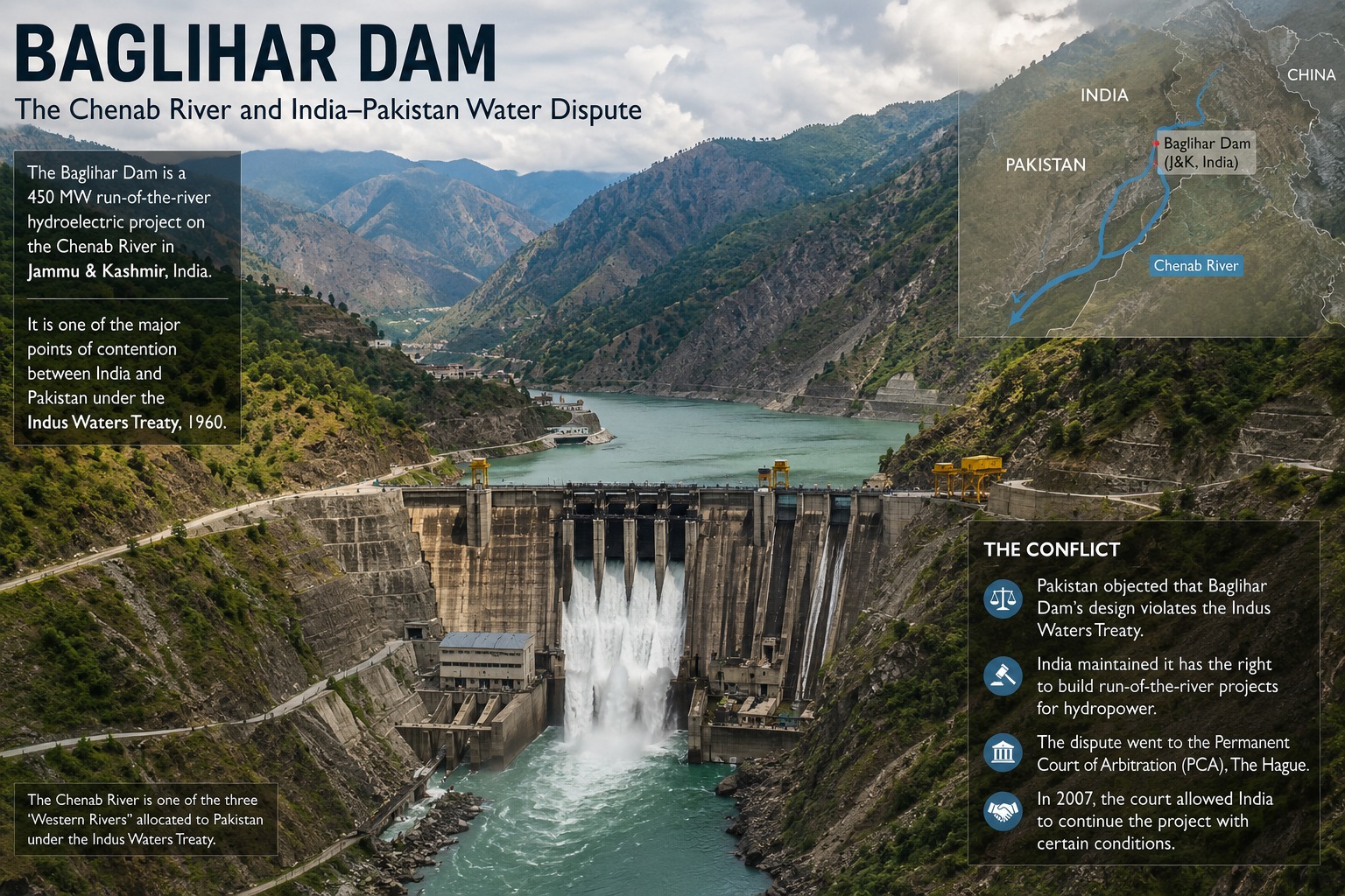
For decades, the waters of the Chenab River have done more than nourish fields and generate electricity. They have carried with them the weight of diplomacy, strategic calculations, engineering, and, increasingly, national security. Every time India opens the spillway gates of the Baglihar Hydroelectric Project in Jammu and Kashmir, headlines quickly emerge across South Asia. Some describe it as a routine engineering exercise. Others portray it as a strategic signal to Pakistan.
This week, following days of intense rainfall across Doda, Kishtwar, Ramban, and other parts of Jammu and Kashmir, Indian authorities opened three gates of the Baglihar Dam to release excess water into the Chenab River. Officials stated that the decision was taken solely to reduce pressure on the reservoir and maintain the structural safety of the dam.
Yet the event has reignited an old debate.
Was this merely flood management? Could India use water as a strategic tool? And why does every operational decision at Baglihar create such anxiety in Pakistan?
The Chenab: More Than Just a River
The Chenab River originates in the Himalayas and flows through Jammu and Kashmir before entering Pakistan, where it becomes one of the country's most important rivers.
Its waters irrigate millions of acres of farmland, sustain rural communities, support hydroelectric generation, and contribute significantly to Pakistan's agricultural economy.
For Pakistan, the Chenab is not merely a river.
It is part of the country's economic lifeline.
Any sudden fluctuation in its flow immediately attracts attention because millions of people downstream depend upon it.
Why Did India Open the Baglihar Dam Gates?
The answer lies primarily in engineering, not politics.
The upper Chenab basin experienced continuous heavy rainfall over several days. Rivers flowing into the Baglihar reservoir carried enormous volumes of water, causing the reservoir level to rise rapidly.
Every dam has a maximum safe operating level.
When inflows exceed the amount that turbines can safely process, operators must release additional water through spillway gates.
This serves several purposes:
1. reducing pressure on the dam;
2. protecting turbines and electrical equipment;
3. preventing uncontrolled overtopping;
4. ensuring the long-term structural integrity of the dam.
In other words, opening the gates was not an extraordinary measure but a standard safety procedure followed by dam operators across the world.
Keeping the gates closed under such conditions could have created far greater risks than releasing water in a controlled manner.
Was Opening the Gates Really Necessary?
From an engineering perspective, yes.
Contrary to popular perception, dams are not giant storage tanks that can endlessly hold incoming water.
Every reservoir has design limitations.
When heavy rainfall continues, inflow may exceed outflow capacity.
At that point, engineers have only two realistic choices:
Either release water gradually under controlled conditions...
or risk dangerously increasing pressure on the structure.
History has repeatedly shown that delaying necessary releases can worsen downstream flooding if emergency discharges later become unavoidable.
Controlled release is therefore considered the safest option.
Why Does Pakistan Become Concerned Every Time This Happens?
Pakistan's concern is understandable.
The Chenab crosses into Pakistani territory shortly after leaving India.
When additional water is released upstream during periods of heavy rainfall, downstream river levels can rise rapidly.
Although flood forecasting systems exist, sudden increases still place pressure on local administrations responsible for protecting populations, crops, bridges, and infrastructure.
Pakistan's concerns become even greater because much of its economy depends upon irrigated agriculture.
Punjab, often called Pakistan's agricultural heartland, relies heavily on rivers originating in the Himalayas.
Any disruption in river flow, whether excessive flooding or reduced water availability creates significant economic consequences.
Can India Intentionally Flood Pakistan?
This is perhaps the most controversial question.
The answer requires separating technical reality from political rhetoric.
The Baglihar Project is classified as a run-of-the-river hydroelectric project.
Unlike massive storage dams, it possesses relatively limited storage capacity.
This means India cannot simply accumulate months' worth of Chenab water and suddenly unleash it whenever it chooses.
During intense monsoon conditions, operators have little choice but to release excess inflow.
Therefore, while dam operations can influence the timing of water flows over short periods, publicly available technical evidence does not support the claim that Baglihar alone can be used to deliberately create catastrophic flooding across Pakistan.
Natural rainfall remains the dominant factor governing flood intensity.
When both heavy rainfall and controlled releases occur simultaneously, downstream flooding risks naturally increase.
The History Behind the Baglihar Controversy
Baglihar has never been just an engineering project.
It has been a diplomatic issue for nearly two decades.
Pakistan repeatedly argued that certain design features of the dam violated the Indus Waters Treaty, expressing concern that India might gain excessive control over Chenab waters.
The dispute eventually went to a neutral expert appointed through the treaty's dispute-resolution mechanism.
The expert required modifications to some technical aspects of the project but largely allowed construction to continue.
The outcome demonstrated an important principle:
Disagreements over dam design can be resolved within the treaty framework rather than through confrontation.
The Indus Waters Treaty: One of the World's Most Durable Water Agreements
Signed in 1960 with the mediation of the World Bank, the Indus Waters Treaty divided the six major rivers of the Indus Basin.
The three eastern rivers were allocated primarily to India.
The three western rivers including the Chenab were reserved principally for Pakistan, while allowing India limited rights for hydroelectric generation and certain other uses.
Remarkably, the treaty has survived multiple wars, military crises, and prolonged diplomatic hostility.
Few international water-sharing agreements have demonstrated such resilience.
However, changing geopolitical realities and climate pressures have placed increasing strain on the treaty's long-term future.
Why Is Pakistan Particularly Vulnerable?
Pakistan today faces a striking paradox.
At one time, parts of the country experience severe water shortages.
At another, devastating floods.
How can a country suffer drought and floods almost simultaneously?
The answer lies in geography, climate variability, infrastructure limitations, and water management.
Most of Pakistan's river system depends upon waters originating outside its borders.
Seasonal monsoon rains, Himalayan snowmelt, glacier melt, and upstream river flows all influence water availability.
Climate change is making these patterns increasingly unpredictable.
Recent years have demonstrated this dramatically.
Pakistan has experienced some of the worst floods in its modern history, causing widespread destruction, while other regions have simultaneously struggled with declining groundwater and irrigation shortages.
The challenge, therefore, is no longer simply obtaining water.
It is managing water.
Could Climate Change Transform Water Into South Asia's Biggest Security Challenge?
Climate scientists increasingly warn that the Himalayas are warming faster than many other mountain regions.
Glacial melt patterns are changing.
Extreme rainfall events are becoming more frequent.
Cloudbursts and flash floods are increasing.
All these developments place additional stress on dams, reservoirs, and downstream communities.
Future disputes may therefore revolve less around deliberate actions by governments and more around managing increasingly unpredictable rivers.
Beyond Politics: The Engineering Reality
One of the biggest misconceptions surrounding dam operations is the assumption that every release of water is politically motivated.
In reality, dam operators follow hydrological data, reservoir levels, weather forecasts, inflow measurements, and engineering safety protocols.
During extreme weather events, decisions often have to be taken within hours—not days.
Safety becomes the overriding priority.
That does not eliminate geopolitical sensitivities.
But it reminds us that engineering realities often shape decisions before politics enters the conversation.
Questions the World Should Be Asking
Instead of asking only whether India released water, perhaps the more important questions are:
Is South Asia adequately prepared for increasingly extreme rainfall events?
Can India and Pakistan strengthen flood-warning coordination despite political tensions?
Will climate change make disputes over river management more frequent?
Can the Indus Waters Treaty continue to function under twenty-first-century climate realities?
Is water gradually replacing conventional military power as the region's most strategic resource?
Conclusion
The opening of the Baglihar Dam gates should not be viewed simply as a dramatic headline. It is the intersection of hydrology, engineering, international law, climate science, and geopolitics.
The immediate trigger was heavy rainfall in Jammu and Kashmir, making controlled water release necessary to protect the dam and downstream communities. Based on the available technical evidence, this was a standard operational decision rather than proof of an attempt to intentionally flood Pakistan.
Yet the event also exposes a larger truth. Rivers in South Asia are no longer just natural resources; they are strategic assets whose management affects food security, energy production, disaster resilience, and regional stability. For Pakistan, whose agriculture and economy remain deeply dependent on the Indus river system, every fluctuation in the Chenab carries significant consequences.
For India, balancing infrastructure development with treaty obligations and regional perceptions remains equally important.
As climate change intensifies and extreme weather becomes more common, the real question may no longer be who controls the water, but whether South Asia can learn to manage its shared rivers before the rivers begin to dictate the region's future.